It’s a busy time when the ice melts. Anglers all across North America are busy planning or packing for fishing travel, and many of these trips will take place in remote areas that have little-to-no connectivity. But a lack of cell phone coverage and Wi-Fi doesn’t mean anglers need to fish blind.
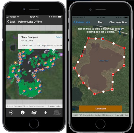
Offline mapping is one of the latest premium features from Fishidy, the popular mobile app and map-based social network for anglers. The feature allows Fishidy Premium users to download any Fishing Hot Spots® map on the app, including depth contours, marked spots, structures and more to their mobile device ahead of time.

“Some of the best fishing happens in the middle of nowhere, where connectivity can be a challenge,” says Fishidy Marketing Manager, Jon Giacalone. “We’ve listened to the members of our Fishidy community, who have told us that this is a pretty common issue. The Offline Mapping feature now provides our Premium members with 100% access to whatever maps they want, whenever and wherever they want them.”
Using Fishidy Offline Mapping is easy; simply select a map area in the app, download it when you have connectivity, and it will be accessible on that device at any time in the future, without the need for phone or internet service.
As the open-water fishing season ramps up, Offline Mapping will have a significant impact on the exploration efforts—and, ultimately, the success—of anglers throughout the North, whether they are fishing remote Canadian lakes, vast bodies of water like Minnesota’s Lake of the Woods, or even offshore areas of the Great Lakes.
Offline Mapping will pay similar dividends to saltwater anglers, who can download maps before heading offshore or into remote backwater areas that lack Wi-Fi or cell phone coverage.
Before you travel to fish, be sure to get the best source of fishing maps and information available. Learn more about Offline Mapping and other Premium Fishidy features at Fishidy.com.
RELATED
